Geophysical Methods
Overview
Geophysical methods measure physical properties of materials that can be used to infer information about the surface and subsurface of the Earth. These minimally invasive to non-invasive methods have been used in oil and mineral exploration since the early 1900s and modified over the past several decades to support the characterization and remediation of contaminated hazardous waste sites. Geophysical methods provide both quantitative and qualitative information. Properties such as electrical resistance, seismic reflection/refraction, or magnetism can be used to interpret geologic characteristics such as porosity, permeability, water content of the formation, and/or mineralogy. Geophysical data can also be used to identify the top of bedrock; other geologic contacts; geologic features, such as joints and faults; and buried objects, including drums and other potential subsurface sources of contamination and potential pathways for contaminant migration (such as more permeable layers in the subsurface). This information will help develop and refine the conceptual site model (CSM).1

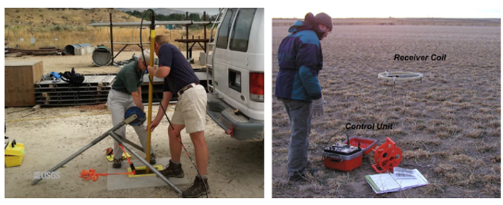
Figure 1. (a) Deployment of a nuclear magnetic resonance (NMR) tool in a borehole (USGS). (b) Deployment of an electromagnetic (EM) tool on the ground surface (Lucius et al. 2006).
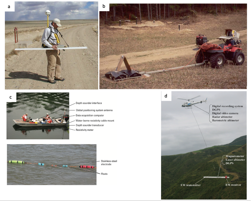
Geophysical tools can be used at the ground surface or in boreholes (Figure 1). These tools can be deployed on a variety of platforms, depending upon site conditions and data needs. For example, simple small-scale surveys can use handheld instruments or instruments towed behind all-terrain vehicles (Figure 2, a and b). However, more complex surveys may employ boats or aircraft (Figure 2, c and d).

Figure 2. (a) Handheld electromagnetic meter (Lucius et al. 2006). (b) Vehicle-towed ground penetrating radar (GPR) equipment (Lucius et al. 2006). (c) Waterborne electric resistivity tomography (ERT) (Ball and Teeple 2013![]() ). (d) Airborne electromagnetic (EM) and magnetometer deployment (Ball et al. 2011
). (d) Airborne electromagnetic (EM) and magnetometer deployment (Ball et al. 2011![]() ).
).
Knowledge of the local and regional geologic setting, as well as historical land use, should always be considered when interpreting the results of a geophysical survey. Because geophysics is an indirect measurement of subsurface features, in some cases a survey can return multiple solutions. It is necessary in these instances to provide more data (e.g., boring log or other geophysics) to constrain the interpretation model. For example, borehole logs can help distinguish whether seismic velocities indicate a sandstone or a shale; historical land use information can help identify whether an anomaly might represent a buried tank or utilities.
When combined with direct sampling data (such as soil boring or groundwater well samples), geophysical data can "connect the dots," enabling correlations between boreholes or wells across the site for a more comprehensive, high-resolution site characterization (HRSC). Data collected via geophysical methods can also identify preliminary areas of concern (e.g., high permeability layers/zones, presence of buried metal) to investigate further. A benefit of geophysical methods is that they are typically non-destructive; for example, surface geophysics options, such as seismic or ground penetrating radar (GPR), can be used to avoid unintentional problems from drilling or excavation, such as back diffusion or contaminant leakage through confining layers.
Determining which geophysical method to apply to a site requires an understanding of each geophysical method and the information needed at the site. A knowledgeable geophysicist can advise which geophysical techniques are most appropriate for exploring various aspects of a particular site depending on the geology, contaminants, soil composition, and other site characteristics.
This CLU-IN focus area discusses the typical uses, theory of operation, system components, modes of operation, data display and interpretation, performance specifications, advantages, limitations, and costs for nine types of geophysical methods:
- Borehole Nuclear Magnetic Resonance
- Electrical Resistivity Tomography
- Electromagnetic Methods
- Gamma Logging
- Gravity Methods
- Ground Penetrating Radar
- Magnetometry
- Seismic Reflection and Refraction
- Self or Spontaneous Potential
The geophysical methods, detection capabilities, and performance specifications are compared in this Excel spreadsheet![]() . Users may sort by mode of operation, detection capability, and other factors.
. Users may sort by mode of operation, detection capability, and other factors.
Resources
Environmental Geophysics
EPA webpage
This website describes geophysical methods, decision support tools, predictive models, and data interpretation models that can facilitate the proper use, application, and interpretation of geophysics to environmental problems. It is intended as a resource for environmental and geoscience professionals, educators, stakeholders, and other interested parties.
A Geophysical Remediation Monitoring Method Selection Tool (GRM-MST)
Thompson, J., et al., Groundwater, 61(1):8-10(2023)
This article provides an overview of the GRM-MST, which helps practitioners identify a geophysical method to monitor remediation operations based on the remediation method being used and site characteristics.
Geophysical Remediation Monitoring Method Selection Tool (GRM-MST)
Thompson, J., A. Mangel, and F. Day-Lewis. Pacific Northwest National Laboratory. Updated October 12, 2022
Download the Excel spreadsheet-based GRM-MST from the link above. GRM-MST can help practitioners identify geophysical monitoring strategies that contribute to study goals and are likely to be effective under site-specific conditions. Users answer questions about groundwater and surface-water-related study goals and site parameters and characteristics. Based on user input, the tool indicates which methods from a toolbox of nine geophysical methods could potentially contribute to achieving site goals.
Advanced Site Characterization Tools (ASCT) Selection Tool
Interstate Technology and Regulatory Council (ITRC). December 2019.
The ASCT Selection Tool is a Microsoft Excel spreadsheet that can be used to evaluate appropriate tools for characterization based on site-specific needs. The user inputs the type of data needed, the type of subsurface, the quality of the data needed, and the data collection characteristics (invasive versus non-invasive).
Fractured Rock Geophysical Toolbox
U.S. Geological Survey. January 6, 2016.
The "toolbox" comprises 30 surface, downhole, and cross-hole geophysical methods. Additionally, hydrologic tests appropriate to fractured rock are included. The user enters information in two tables for site parameters and project goals. Based on user entry, a third table is populated with indicators for which methods support specified goals and are feasible at the site. Worksheet appendices provide detailed information on various methods.
![]() Geophysical Exploration for Engineering and Environmental Investigations
Geophysical Exploration for Engineering and Environmental Investigations
U.S. Army Corps of Engineers, EM 1110-1-1802. 208 pp. August 1995
This document is an overview of geophysical exploration methods used for engineering, geological, and environmental investigations. Descriptions of geophysical methods used in these investigations are provided, along with guidance on their applicability.
Use of Airborne, Surface, and Geophysical Techniques at Contaminated Sites: A Reference Guide
U.S. Environmental Protection Agency, EPA/625/R-92/007. 304 pp. September 1993
The guide describes both commonly used and less commonly used geophysical methods using nontechnical terms. The guide is targeted for non-geophysicists investigating and monitoring contaminated sites. References for more detailed information from major texts and reports are provided. The applicability of the various geophysical methods to different site conditions is provided. Summary information on case studies of the use of the various methods is provided in Appendix A.
Subsurface Characterization and Monitoring Techniques: A Desk Reference Guide – Volume 1: Solids and Ground Water – Appendices A and B
U.S. Environmental Protection Agency, EPA/625/R-93/003a. 498 pp. May 1993
This document was designed to be a single comprehensive source of information on existing (1993) and developing field methods for the investigation, characterization, and remediation of contaminated sites. The document provides an overview of techniques and methods used to develop site characterization and monitoring plans. Summaries of specific methods, including their application, major advantages and disadvantages, and references, are provided.
References:
Ball, L., et al., 2011. ![]() Airborne Electromagnetic and Magnetic Geophysical Survey Data of the Yukon Flats and Fort Wainwright Areas, Central Alaska, June 2010. U.S. Geological Survey Open-File Report 2011-1304, 21 p.
Airborne Electromagnetic and Magnetic Geophysical Survey Data of the Yukon Flats and Fort Wainwright Areas, Central Alaska, June 2010. U.S. Geological Survey Open-File Report 2011-1304, 21 p.
Ball, L. and A. Teeple, 2013. ![]() Characterization of Major Lithologic Units Underlying the Lower American River Using Water-borne Continuous Resistivity Profiling, Sacramento California, June 2008. U.S. Geological Survey Open-File Report 2013-1050, 13 p.
Characterization of Major Lithologic Units Underlying the Lower American River Using Water-borne Continuous Resistivity Profiling, Sacramento California, June 2008. U.S. Geological Survey Open-File Report 2013-1050, 13 p.
Lucius, J., et al., 2006. An Introduction to Using Surface Geophysics to Characterize Sand and Gravel Deposits. U.S. Geological Survey Open-File Report 2006-1257, 51 p.
U.S. Environmental Protection Agency (U.S. EPA), 2008. ![]() Triad Issue Paper: Using Geophysical Tools to Develop the Conceptual Site Model. Office of Solid Waste and Emergency Response, 542-F-08-007, 15 p., December.
Triad Issue Paper: Using Geophysical Tools to Develop the Conceptual Site Model. Office of Solid Waste and Emergency Response, 542-F-08-007, 15 p., December.
U.S. Environmental Protection Agency (U.S. EPA), 2011. ![]() Environmental Cleanup Best Management Practices: Effective Use of the Project Life Cycle Conceptual Site Model. Office of Solid Waste and Emergency Response, 542-F-11-001, 12 p., July.
Environmental Cleanup Best Management Practices: Effective Use of the Project Life Cycle Conceptual Site Model. Office of Solid Waste and Emergency Response, 542-F-11-001, 12 p., July.
U.S. Environmental Protection Agency (U.S. EPA), 2018. ![]() Smart Scoping for Environmental Investigations Technical Guidance. 542-G-18-004, 19 p., November.
Smart Scoping for Environmental Investigations Technical Guidance. 542-G-18-004, 19 p., November.
Helpful Information
-
A conceptual site model (CSM) is an iterative tool used by project teams to summarize and visualize available information on a site, as well as uncertainties associated with that information to support project and site decision-making through the entire life cycle of investigation and cleanup of a site. The CSM not only supports technical decision-making but also is a useful tool for communication and consensus-building with stakeholders (EPA 2018; EPA 2011). ↩

